Des images satellites aux estimations de population
Des images satellites aux estimations de population
Séminaire Population, climat et environnement
20 Mai 2021, 11h-12h30 en vidéoconférence
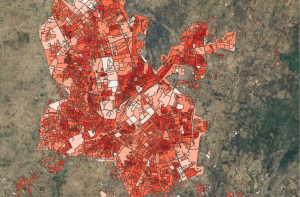
Les images satellites constituent une masse d’informations sur les implantations humaines et peuvent à ce titre constituer des données d’une grande richesse pour estimer la population, particulièrement dans les régions ne disposant pas de recensement de population récent ou à des moments où la collecte de données n’est pas possible. Deux approches différentes seront abordées ici.
Lien Zoom : https://ined-fr.zoom.us/j/99505490145?pwd=eUZxK1JmNUZ0LzZvSGNzTTJZZzZNZz09
ID : 995 0549 0145
Code secret : 953924
Population from space: when satellite imagery helps demographic census in insecure context
- Edith Darin (U. Southampton, Worldpop)
We will offer first an overview of the different gridded population datasets and models produced by WorldPop, their advantages and limitations. The second part will be devoted specifically to the GRID3 initiative that develops bottom-up population modelling extrapolating localized population data with geospatial covariates in a hierarchical Bayesian framework.
En savoir plus : Résumé
How TeleCense helps Companies, Authorities, International Organizations and Labs to assess and anticipate population growth and migration in emerging countries
- Léo Lipovac, Steven Guern and Michel Benet (Diginove)
Using Copernicus satellite imagery, we are able to detect built-up areas and to characterize them. Using these characteristics along with other geospatial covariates, we develop demographic models to estimate the population. The regularity of Copernicus images allows us to follow its evolution on a 6-month basis and provide local and global trends.
En savoir plus : Résumé